Hugh Raffles
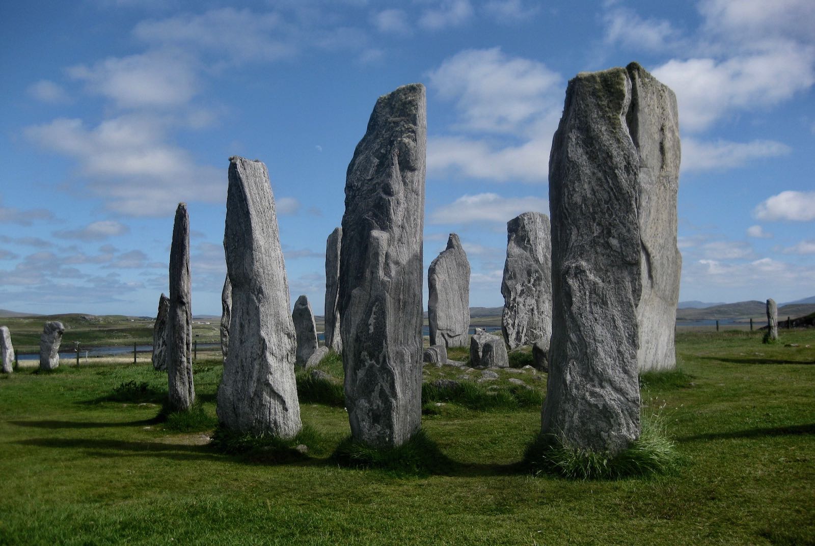
The stones of Callanish (Calanais), Isle of Lewis, Scotland, 2010
At Ullapool, on the Scottish mainland, I waited for the ferry to Stornoway, the only town on the Isle of Lewis, the most northerly of the Outer Hebrides, the Western Isles. It takes two and a half hours to cross the Minch, the forty-mile strait formed 1.2 billion years ago when a meteorite blasted a channel between what are now the Northwest Highlands of Scotland and these outlying islands. Sitting in the pale sunlight, considering the enormity of that fiery descent and ferocious impact, I was all at once flooded with the memory of being here before, at Ullapool, in this same line, waiting for this same Caledonian MacBrayne ferry, the very same boat, in fact, in what must have been late December 1975.
I was with my sister Franki and her boyfriend, Martin, in their overheated car with its steamed-up windows, and we were on our way to the falling-down farmhouse that they, hippie Marxist homesteaders, were rebuilding at Callanish (as it was called before Gaelicization restored it to Calanais), just below the famous standing stones, the so-called Stonehenge of the North. Ullapool was already the furthest north I’d then been, but we were going further, heading across the water into uncharted emptiness, it seemed to me. But I was with Franki, so it was the emptiness of possibility, not of the void.
The void came two decades later, on an unseasonably warm evening, December 8, 1994, when the phone rang in my two-room New York City apartment on the fourth floor of a building on Tenth Street, just west of Second Avenue. It was my sister Emma, who told me that Franki had died, without warning, after hemorrhaging under anesthetic in Edinburgh Hospital while giving birth to twins. So now, back in Ullapool for the first time in many years, and seeing again the same battened-down buildings, the same gray water, the same postcard port, the same narrow streets, all apparently unchanged yet now made quite different by the disquiets of time, I remembered that when I answered that call, the image that flooded my mind was of the hillside behind Franki’s house: the climb to the stones, there in the dark, on the crag, above the sea, above her house, facing the hills, on the Isle of Lewis, the most northerly of the Western Isles.
*
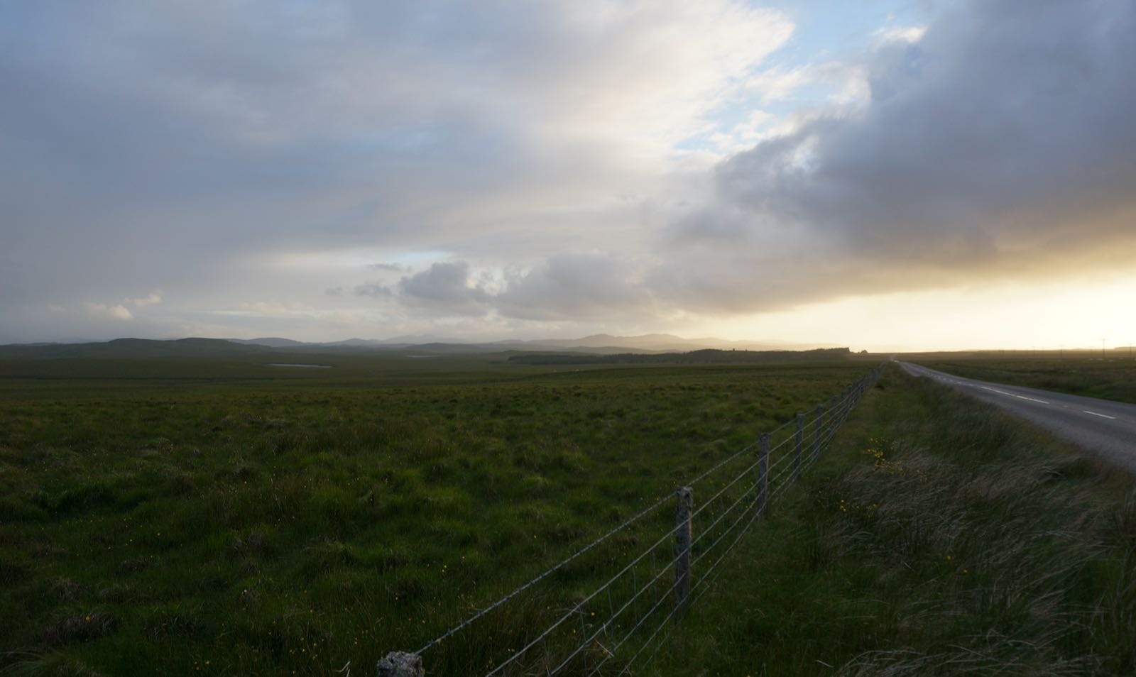
Lewis is breathtaking in its bleakness. The seventeen-mile drive across the island from Stornoway to Calanais should take thirty minutes, but I kept stopping, forced to a halt by the stillness, the silence, the simple force of the views.
Hugh Raffles
The Isle of Lewis, Scotland, July 2013
Lewis is a small place, but its story is immense. Four hundred and forty thousand years ago, ice, in places almost a half-mile thick, covered this land, turning the Outer Hebrides into something like northern Greenland today. The ice flowed east across the Minch to Scotland and back again; it flowed west into the ocean as far as St. Kilda, more than forty miles offshore. It transfigured the islands, scouring and splitting the bedrock, gouging out valleys and hills, advancing and retreating until the onset of warmer temperatures and heavy rains around 7000 BCE. The landscape it left was ragged and dramatic: roches moutonnées, whalebacks, crag-and-tail ridges, and frost-shattered pinnacles; giant erratics and smaller boulders dropped far from their origins; the desolate cnoc-and-lochan moors that trap the northern sun in countless pools like a splintered mirror.
As the ice ages melted away, the peat bog that now blankets much of Lewis began to grow. That peat, formed mostly from sphagnum moss and heather buried and compacted in acidic, waterlogged soils above the impermeable glacial till, was once the sole fuel for the island’s crofters; and even today, it’s cut and stacked to dry in dark, cairnlike piles. The peat here can be four thousand years old and deep enough to disguise or entirely cover ancient monuments. And below it, below the glacial till, is the bedrock, Lewisian gneiss, close to three billion years old, among the oldest rock on the planet, rock that started life as churning magma dozens of miles underground in the Earth’s mantle, cooling, solidifying, and crystallizing into igneous granites, granodiorites, tonalites, basalts, and gabbros, then buried, reheated, sheared, and recrystallized, crushed, twisted, stretched, pressed, and folded in at least two major metamorphic, mountain-building events occurring over the next 1.5 billion years—warped and recast in such tortured ways that their original features, the defining traits of the protoliths of these islands, were thoroughly erased.
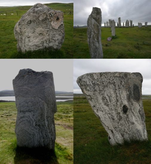
Lewisian gneiss, in the words of the archaeologist Colin Richards, is “rock that once seen and handled is never forgotten.” Returning from Calanais one summer afternoon, I picked up two unassuming, hand-sized blocks on a jagged hillside littered with glacial debris as if from the aftermath of a planetary collision. As I write, they sit before me on the table: rough, coarse-grained granitic rocks, one with thick, confused layers of pale pink, the other larger, darker, “houndstooth stone” Seamus Heaney might have called it, implacable and exacting, he might have said, stippled black and gray matrix, thin parallel pink veins. One billion years ago, following millennia of uplift and erosion, the gneiss breached the surface with its psychedelic ripples and baroque bands—the gray and pink of quartz, feldspar, and granite; the dark green and black of hornblende and biotite mica. Resting on the sidelines in the Hebridean terrane, a foreland of the North American craton Laurentia on the margins of the long-closed, ancient Iapetus Ocean, it escaped the tectonic drama of the Caledonian orogeny, and so preserved the evidence of far older geological events.
Advertisement
The most solid of rocks, they’re heavy; wary of dropping them, I hold them tight and think of them traveling through the frozen earth, the floating earth, the molten earth, the places they’ve been, the life they’ve seen, two-thirds of the way back to the beginning of the planet, far beyond the Ordovician with its horseshoe crabs, its cartilaginous fish, and its marine mass extinctions; far beyond the Cambrian with its trilobites, its brand-new chordates, and its paradigm-confounding explosion of multicellular organisms, the first eukaryotic cells, and the build-up of atmospheric oxygen; back beyond the Proterozoic and into the Archaean, the formation of the first bacteria and the first continental plates, an unsettled, still-cooling planet taking shape beneath an ammonia-and-methane-filled atmosphere; stopping just short of the lip of emptiness, the cusp of what geologists imagine as a liquid surface of swirling gas, brimstone, and fire, the hellish Hadean.
*
The A859 road to Calanais follows the stream of the Black River through northern Lewis, keeping close to what was probably the main land route to the monument in Neolithic times.
Approaching from the east, a succession of circles is silhouetted starkly against the sky on hilltops and outcroppings above the valley. Colin Richards and his team walked this and a second route to the principal monument at Calanais. It was as if they were moving through “a process of unwrapping,” a theatrically structured and choreographed journey in which concealment progressively gives way to unveiling as the protected central space is neared. Richards and his colleagues decided that the sites they passed were something like movie flats, simulacra of monuments—circles flattened into ellipses to increase the visual impact from below, slabs selected for their prominent veins of reflective quartz and positioned to catch the sun, large stones propped up with blocks rather than mounted in sockets—quick, jerry-built structures in an architecture of deception and illusion.
Hugh Raffles
Standing stones, Lewis, 2013
By contrast, ever since the arrival of the writer Martin Martin in 1696, visitors have recognized that the central monument and its satellites were built to last. Martin, a native of nearby Skye, traveled to Lewis at the behest of the antiquarian, collector, and founding benefactor of the British Museum, Hans Sloane, then secretary of the Royal Society. A speaker of Gaelic, graduate of Edinburgh University, and tutor to chiefs of the Highland clans, Martin could move between two elites—the ideal envoy to a region that was as remote, primitive, and exotic to most Scots as it was to the London literati. Calanais, he reported, was “a place appointed for worship in the time of heathenism” where “the chief druid or priest stood near the big stone in the center, from whence he addressed himself to the people that surrounded him.” Set high on its broad ridge, the site had an unusual cruciform layout. An imposing avenue leads to a small circle dominated by a giant monolith nearly fifteen feet tall; additional, shorter avenues reach out from either side, and, to the south, a single line of stones once stretched all the way to Cnoc an Tursa, a large outcrop of Lewisian gneiss, the rocky crag a hundred feet above sea level that I used to climb from Franki’s house.
*
I was shouldering a heavy red backpack belonging to the researcher Margaret Curtis as she strode briskly ahead of me between the stones. The monument was laid out around 3000 BCE, and, soon after, a chambered cairn was built in its center. Sometime between 1500 and 1000 BCE, the site was ransacked and then harrowed—probably by Bronze Age farmers, perhaps to neutralize and negate its power—and it fell into centuries of disuse. Peat five feet deep accumulated here in the millennia following this abandonment until, in 1857, the island’s owner, Sir James Matheson, ordered his men to remove both the peat and the local crofters, and to erect a platform over the just-discovered cairn, so that his wife and guests could view the newly imposing stones and their tidemarks.
Advertisement
Matheson had purchased the entire Isle of Lewis in 1844 for £190,000, just a fraction of his fortune from Jardine, Matheson & Co., the Hong Kong-based trading firm he founded in 1832, more an empire than a firm, the most powerful of the British opium-trading houses. (It survives to this day—as a vastly diversified holding company with interests that span financial services, supermarkets, engineering, cars, restaurants, mining, property, and agribusiness.) Matheson was only forty-six when he retired to the Hebrides and built Lews Castle, the mock-Gothic fortress that dominates Stornoway Harbor and commands the eye as the ferry cautiously maneuvers its way into the sheltered port. Just visible within the walled grounds is the Matheson Monument, a white neoclassical confection with Greco-Roman columns topped by opium poppies that frame a statue of a nymphlike woman, her face cast down in a gesture of Victorian modesty. On its pedestal, Lady Mary Jane Matheson’s inscription describes her husband as “a child of God, living evidently under the influence of His Holy Spirit,” a formula that captures the evangelical thrust of even the murkiest colonial enterprise.
My sister Franki was a photographer, and so, it happens, was Lady Matheson, an amateur in an age when it was unusual although not unknown for wealthy women to take up the new technology. Franki made documentary images, almost exclusively of women, images with a strong ethnographic sensibility, often of women at work, in Russia, China, and Israel, but mostly in Scotland, emphasizing strength, endurance, resilience, solidarity, but also social precarity—images frequently produced in collaboration with Scottish feminist and left campaigns and organizations. Many of Lady Mary Jane’s photographs were of women, too—of friends and relatives, visitors to Lews Castle—portraits taken in the grounds using unwieldy wet-collodion plates, salted paper and albumen prints that open an enigmatic window onto a dreamworld of picnics, shooting parties, and parlor games created by people who must surely at times have wondered why they’d chosen to live their lives on this far-flung island that within a few years of their arrival was visited by pestilence and starvation.
In 1846 and 1847, potatoes, the subsistence crop of the cottar subtenants who composed nearly half the population on some Hebridean estates, failed almost entirely. Extended wet weather provided ideal conditions for Phytophthora infestans, the potato blight that was bringing catastrophe to Ireland, and which, in the Highlands and Islands, although less extreme, produced many of the same effects—famine, enclosure, and emigration—effects exacerbated by the agricultural reforms that Matheson began implementing as soon as he arrived on Lewis. Three-quarters of the landed estates in the Highlands and Islands had changed hands during the first forty years of the nineteenth century. And it was men such as Matheson, with income from sources that freed them from having to make their estates pay—colonial trade, industry, and the professions—who swept away the hereditary lairds and the old way of life. With the blight presenting an opportunity for broad transformation, Matheson drew up emigration programs for cottars and crofters who fell into arrears, as well as for residents of townships located on land suitable for sheep grazing. Between 1851 and 1854, the Stornoway Sheriff ’s Court issued twelve hundred eviction notices on an island with a population of less than nineteen thousand. In the decade during which the famine raged, close to fourteen thousand people left the Hebrides to begin uncharted lives in North America.
*
It took a minute for Margaret Curtis to retrieve the wooden board on which she’d neatly taped an 1854 engraving made by James Kerr, Matheson’s clerk of works, that shows idealized crofters collecting peat from a deep cut across the east row of the monument. Margaret sheltered in the lee of a large stone, gneiss studded with gleaming black hornblende, and rummaged in the giant rucksack on my back. Summer on Lewis, the wind blowing a gale—Margaret’s long white hair flapping gaily in the wind.
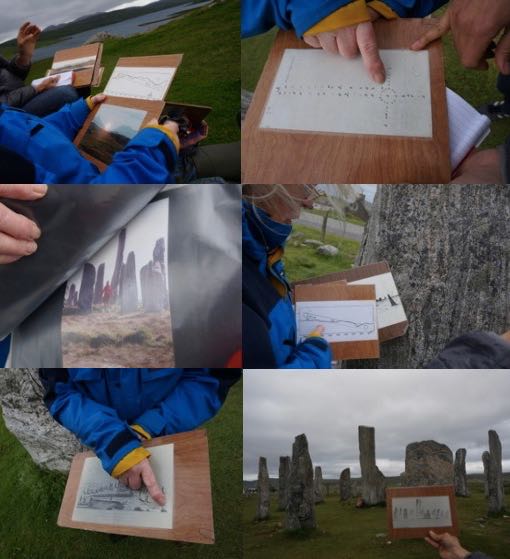
Hugh Raffles
With Margaret Curtis, archaeological researcher, Callanish, 2013
Margaret wants Calanais included on the UNESCO register of World Heritage Sites. She juggled maps and boards, pulling diagrams and photographs from the backpack like a conjuror, pointing out alignments and azimuths, foresights and backsights, horizon points and declinations, sky, landscape, and stone. She demonstrated for me how she’d used the surveys drawn by Martin Martin and those who followed him to track the history of a monument that has consumed her since she arrived here in 1974, fleeing rural Suffolk with her first husband, disillusioned with the urbanization of the English countryside and moving into a house less than a mile from the stones, where, like Franki and her Martin, they pursued “a crofting lifestyle with hens, goats, sheep, vegetables, haymaking and peat-cutting,” as they described in one of the books they later wrote about their research on the stones.
Margaret marched me around the stones, laying out the case for the monument as an astronomical temple aligned so that every 18.6 years—when the moon’s monthly swing is at its widest—a viewer standing at the north end of the avenue would witness the huge full moon, low on the horizon at this latitude, skimming the hills to the south, disappearing, then dramatically “re-gleaming” within the circle as it passes through a deep notch in the Clisham hills to the north. The official sign at the main site reads: “The purpose of the stones remains a mystery…Elsewhere the builders clearly oriented monuments according to astronomical events such as the midwinter sunrise and sunset. It is unclear whether this was the case at Calanais.” But Margaret was undeterred. She showed me the reattached tip of a broken stone that she’d found built into the wall surrounding the site, and another stone that had been buried until she located it and had it raised.
Afterward, over tea and cake in the visitors’ center, she told me about the goddess worshippers and Earth mysteries believers who have flocked to Calanais since she began her work, about the psychics and American Indian healers she’s met here, their intense reactions to the site, their visions of processions of menstruating women in flowing blue robes. As she talked, I suddenly realized that Franki’s house was demolished to make way for the glass-walled café in which we were sitting. “It’s the gaps in the circle that matter, not the stones,” Margaret said, as if catching my thought, and pulled out a photograph of a giant red moon pouring its fire into the monument.
*
At the south end of the monument, the stones lead to Cnoc an Tursa, above where Franki’s house used to be. Both Margaret Curtis and Colin Richards agree that, at one time, a row or avenue of stones would have extended all the way here from the circle. A modern stone wall now cuts it off from the main site, but once the alignment has been pointed out, the crag’s status as the climax and focal point of the entire complex seems indisputable. Cnoc an Tursa is cleft by a fissure that cuts right through it. From above, it forms a straight line that, as Margaret shows me, points directly to the hills in the south. From the front, approached from the circle, the cleft is a dark opening, a hole that, as Richards says, appears to be an entrance into the rock itself.
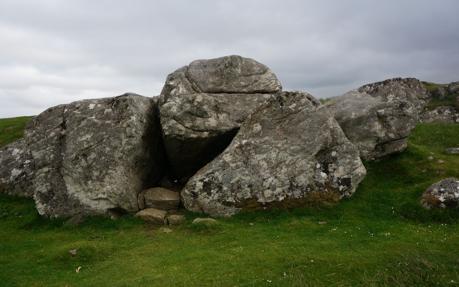
Hugh Raffles
Cnoc an Tursa, Lewis, Scotland, July 2013
At one time, a large monolith stood directly in front of this opening. Though it was later removed, there is evidence of fire and other activities in the same location and of two burial cairns on the top of the crag. If, as many archaeologists believe, Calanais was the center of the Hebrides and of a seagoing northern Neolithic world that encompassed Orkney, the Boyne Valley in Ireland, and Carnac in Brittany, perhaps Cnoc an Tursa was the sacred center of Calanais. Perhaps everything led here, yet another rocky cleft into yet another determinant world, the sulfurous Hadean, the faded albumen prints, the stubborn vitality of even the most dead things, yet another axis mundi linking worlds as unbreachable today as they were five thousand years ago. Unbreachable and unfathomable, but no more so, to me, than the twenty-five years since my sister died. Standing at the entrance, I felt her somewhere near. If only I knew the rituals required. Perhaps then this cleft would open wide and swallow me, too.