
Miguel Schincariol/Getty Images
A burial at Vila Formosa cemetery during the coronavirus pandemic, São Paulo, Brazil April 1, 2020
The first Westerner known to portray human suffering from above was the Flemish Renaissance painter Joachim Patinir, born in Flanders circa 1480. Patinir is considered the inventor of what we now call Weltlandschaft, world landscape, which shows a panoramic cornucopia of landforms and manmade habitats from an elevated perspective that dwarfs the painting’s human subjects.
Patinir specialized in depicting forced migration. This makes sense: like today’s world, in which one billion people are migrants, early Renaissance Europe was delineated by human movement; some scholars estimate that one in nine people on the continent was on the move. There were refugees fleeing religious persecution, hunger, and wars; Jews and Muslims expelled from Southern Europe; pilgrims; merchants trafficking enslaved people from Africa; Europeans en route to the new colonies in the Americas; itinerant laborers. Patinir was a migrant himself.
What did Patinir see, from his altitude? Atrocity. In Landscape with the Destruction of Sodom and Gomorrah (circa 1520), blazing fortresses that look as if they had just been carpet-bombed rise, ridge upon devastated ridge, out of a burning plain; doomed citizens run from a castle toward a river red with the reflected inferno (or maybe with blood); behind them, a row of windmills throws up their charred sails in a tragic pis aller; heaven rains fire and what is not aflame appears covered in soot—except for the bottom right section, where two tiny, insufficient-seeming angels are leading the minuscule Lot and his daughters through a tunnel into a calm and peaceful light. In Landscape with Charon Crossing the Styx (1520–1524), a diminutive, naked soul sails halfway between the blue vistas of heaven and the charred strata of hell, where demons impale, hack, and burn the souls of sinners; it is unclear to the viewer (and perhaps to the soul) where the soul in Charon’s boat will end up. Maybe the make-believe elevation—this low-flying bird’s-eye view—served to allow the viewers a respite: had we been eye level with this horror, we, like Lot, might have felt the urge to flee and never look back.
Using an aerial viewpoint to illustrate catastrophe quickly became convention for sixteenth-century European artists, and migration a recurrent subject. Of the many Weltlandschaft renderings of migration, perhaps the most famous is Pieter Bruegel the Elder’s Landscape with Flight into Egypt (1563). Bruegel, also a migrant (born in the Dutchy of Brabant; died in Brussels, Belgium), has crowded the painting with anecdotal detail: in the foreground, two birds sit in a tree next to a broken pagan shrine; beyond, boatmen pole across a meandering river or inlet toward a wholesome distant city. There are gardens of plenty, faraway mountains, gauzy clouds. At the bottom center of the painting, the Holy Family and their donkey, small as an afterthought, seem to be headed in the direction of a frail footbridge that spans a dark chasm, which two heavily laden wayfarers (how far have they come?) are crossing toward another who appears to be resting—maybe their companion who has already crossed, or maybe someone giving them the right of way before traversing in the opposite direction. Everyone, everything, is seen at that odd remove. Had it not been for Mary’s carmine cloak and the shimmer of her white veil and the Christ’s white bonnet, they would have passed through the landscape unnoticed, like so many migrants.
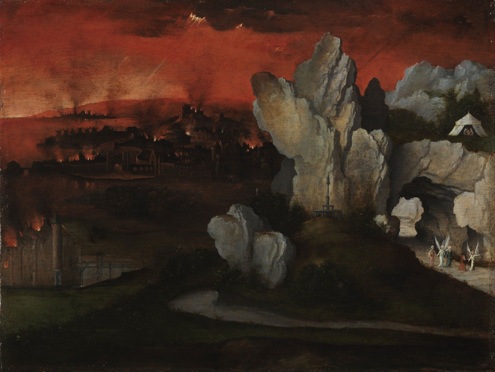
Joachim Patinir: Landscape with the Destruction of Sodom and Gomorrah, circa 1520
Over the past year, as I have been working on a manuscript that contemplates different ways of looking at loss and migration at a time when the very intimate trauma of individual displacement has reached a global scale, I have spent a lot of time studying panoramic images that show tragedy from above. Since the time of Patinir and Bruegel, the bird’s-eye view almost invariably has been a way to document traumatic human events, though not always for humanitarian purposes: historically its principal aim has been to give the military a better sense of its targets of destruction, or their aftermath; whoever has the view has the advantage. But, four hundred years after Patinir, the all-seeing viewpoint once again turned to surveying disaster and atrocity in order to elicit compassion: How better to demonstrate the scale of suffering and motivate us to political action than to zoom out? And, once more, the viewfinder focused on the greatest humanitarian crisis of our time, mass migration. But the more images I looked at, the more conflicted I felt. The bird’s-eye view—or the roving eye of God—left me strangely uninvolved, detached enough to scroll on.
*
The word migrant first appeared in the English language in the seventeenth century as an adjective for animals that are “changing place.” It was not used to describe humans until 1807, by a Congregational minister writing about the colonial history of New Hampshire: its very etymology chronicles the dehumanizing of the non-settled—an attitude that over the centuries has not evolved, much. (Here is Toni Morrison in The Bluest Eye: “Cholly Breedlove…having put his family outdoors, had catapulted himself beyond the reaches of human consideration. He had joined the animals.”) The comparison persists: in 2015, The New York Times wrote of the photographer Rocco Rorandelli’s documentation of human movement from the air: “His photos are reminiscent of aerial images of the migrations of herds.” Teju Cole pointed out the objectification of the migrant in one of his piercing essays on photography, writing about a bird’s-eye-view image of people in line at the Moria camp for migrants in Greece (Cole used the verb “snaking”): “They are waiting to be allowed to be human.”
Advertisement
I search for “aerial photography mass migration” and the first page of Google results is entirely about animals. Wildebeest, zebra, buffalo. I add “human” to my search and filter the results to display images only. My screen populates, first with the beadwork of thousands of people on a bridge across the Usumacinta River that divides Guatemala and Mexico; then a stripe in the Balkans’ fallow fields pixelates into a column of people trudging toward imagined shelter, and hundreds of tiny faces stare up from a rescue boat on the Mediterranean Sea crammed so full of human bodies I can hardly see the deck. When I squint, the bright, zigzagging worm crawling along the no-man’s-land between Greece and Macedonia in a drone image from 2015 proves to be people waiting in line to enter a temporary camp.
Were you perhaps among the pilgrims? It is impossible, from such a distance, to see your individual yearning for safety and dignity, the splendor of your loving, the fracture of your farewells.
I am a migrant: I moved from Russia to the United States in 2004. Of the estimated billion migrants living on earth today, one quarter have crossed political borders; I am one of them. If we were to be corralled into one country, its frontiers would comprise the fifth most populous nation in the world.
The first camp for migrants I visited, in April 2001, lay on a prairie outside Agjabedi, Azerbaijan. It was a temporary home to 3,358 refugees from the war in Nagorno-Karabakh, Europe’s oldest ongoing armed conflict that, by then, had claimed 30,000 lives. The people had arrived at the camp in the early 1990s and scooped shallow caves out of the prairie, hanging bright crimson carpets on the walls so that clumps of dry soil would not fall on their beds. Like the Little Prince, who began each day by pulling out baobab sprouts on his tiny planet, each daybreak they swept out the snakes and frogs that had crawled into their caves overnight. The day I visited, the dugouts were damp. In a cave that belonged to a man named Rashid, we warmed our fingers against glass cups of hot tea.
The conflict over Nagorno-Karabakh began in 1988, when in the Soviet Union aerial war photography was typically classified. I have never seen aerial photographs of the Agjabedi refugee camp. What would they have shown? Mud. Grass. Errant sheep ambling past bits of plastic the residents had pinned to the ground with bricks, to keep earth from leaking on them. Hard to take in from the air the waiting for years in underground caves for a war to end.
*
“We assume that if we raise ourselves high enough, we will see clearly and understand perfectly the view beneath us,” Caren Kaplan writes in her 2018 book Aerial Aftermaths: Wartime from Above, a comprehensive history of the use of aerial photography to document warscapes. Elevation means looking down at things, rising above them, and so it exhilarates with an impression of power: this is why we build rooftop terraces and observation decks; why, as teenagers in the Soviet Union, my friends and I would make illicit excursions to Leningrad’s interconnected rooftops, lifting ourselves for hours at a time above the dreary police state six stories below. But the photos of migrants from the Google page on my screen leave me feeling disempowered. I, the viewer, cannot participate in what I see. The refugees, holy and not—at least not to my knowledge, not yet—plod into exile unassisted by my distant gaze. The rooftop deck becomes a widow’s walk where the viewer wrings her hands in impotent despair until, like Lot, she moves on and never looks back.
“Proximity ignites empathy: you need to be speaking distance to that person,” my friend the documentary photographer Kael Alford tells me. Kael and I met in Iraq in 2003, where we were both documenting the early ravages of that invasion. She recalls the war photographer Robert Capa’s dictum: “If your photographs aren’t good enough, you’re not close enough.” In The Rings of Saturn (1995), W.G. Sebald writes about his visit to the panorama of the Battle of Waterloo (a nine-hour walk from where Patinir was born, a twelve-hour walk from where he died), alerting us to the “falsification of perspective” inherent to the sweeping view from above, a distortion not visual but emotional: “The desolate field extends all around…. Are we standing on a mountain of death? Is that our ultimate vantage point? Does one really have the much-vaunted historical overview from such a position?” I begin to think that an aerial photograph exposes the human condition twice: first, by depicting the scope of tragedy we have at best allowed, and at worst caused—and then, by confronting us with the distance from which we have chosen to view it.
Advertisement
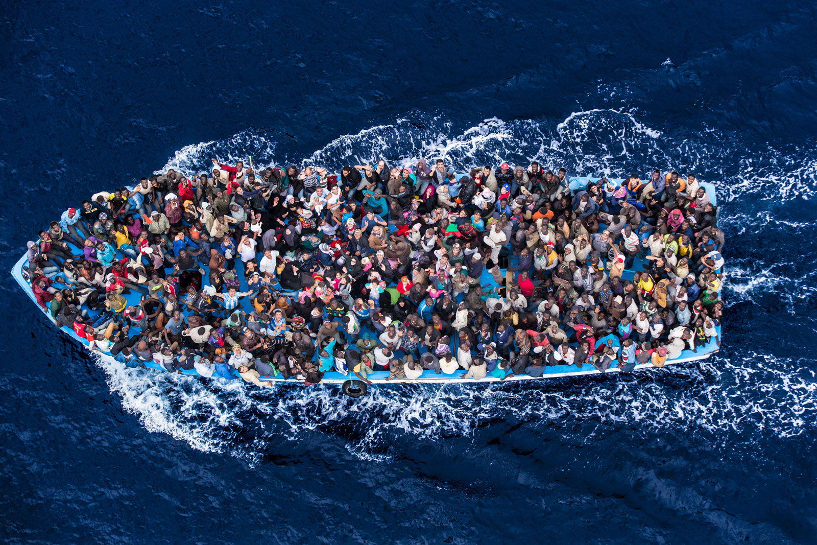
Massimo Sestini/Polaris
Italian navy rescuing asylum seekers traveling by boat off the coast of Africa on the Mediterranean, June 7, 2014
I think of Alice Oswald’s book-length poem, Memorial (2011), in which she winnows the Iliad down to “an oral cemetery…an attempt to remember people’s names and lives.” The result is a kind of escalating lament, both for the soldiers dead at Troy and for our inadequacy before their memory:
Thousands of names thousands of leaves
When you remember them remember this
Dead bodies are their lineage
Which matter no more than leaves
Oswald says her intention is to distill Homer’s epic to what she calls the poem’s enargeia, which she translates as “bright unbearable reality,” “as you might lift the roof off a church in order to remember what you’re worshipping.” An aerial image, in a way, also lifts off the roof of a church to remind us of something fundamental—can we bear it?
*
By the 1940s, aerial photography to catalog, spy, and assess bomb damage was “a highly technical skill and art—but this was mostly of places and things,” another wartime photographer friend, Alan Chin, tells me. Looking at the exceptions, one can argue that the distant gaze turns people into things: in a Luftwaffe photograph, the exhumed bodies of some of the 4,443 Polish officers the Soviet Union had massacred in Katyn Forest in 1940 are laid out like the pale corolla shed by a dead flower; thousands of Muslim refugees preparing to leave for Pakistan after the 1947 Partition of India spume like white milk froth upon the soil to which they suddenly no longer belong.
But it was not until the twenty-first century that aerial imagery of catastrophic events became the purview of photojournalism, readily available to a broad lay audience. Kaplan, in her book, attributes the shift to the increasing availability of images because of the Internet and the globalization of the media, and to the Western audience’s widespread and unchallenged belief that it has the right to look. The Renaissance painters used distance to convey the unknowable magnificence of God’s creation; an aerial photograph of a disaster displays the consequence of the unfathomable wickedness of man. Both are seductive. The more accessible the air becomes—you can buy a drone with a camera online for under $60—the more accessible the unholy spectacle below.
Today, most aerial photographs are indeed made with drones. Often, they are made for reasons more urgently humanitarian than daily journalism: for instance, drones in Bangladesh document the size of and conditions in Rohingya refugee camps; relief workers can access these photographs from their cell phones through cloud-based databases. But drones, too, are used more and more as tools of modern warfare. President Bush authorized fifty-seven known drone strikes against suspected military targets in Africa, Central Asia, and the Middle East; President Obama authorized more than five hundred; President Trump authorized 2,243 drone strikes in the first three years of his presidency. “Protected by a buffer of continents and vast oceans, the United States wages war in such a way that most people at home do not have to think about geopolitics or casualty figures at all,” writes Kaplan. Does aerial imagery desensitize the viewer? By 2014, the widespread US military slang term for images of humans killed in drone strikes was “bug splats.”
When you look at a drone image, think of the layers of removal it both represents and embodies—the drone operator with the viewfinder can be on one continent, the drone and the people in its focus on another, the person viewing the resulting image on a third—and, at the same time, of the mind-numbing, horrifying compression: the drone taking a picture of an atrocity can also be the same drone perpetrating the atrocity. It is a perversion of a perversion, a frontline snuff selfie taken with a remote.
This autumn, the violence over Nagorno-Karabakh began anew. Azerbaijan’s president Ilham Aliyev directly credited weaponizing drones to target Armenian positions with a decisive military advantage during the forty-four days of fighting, which ended in a cease-fire on punishing terms for Armenia; many of the visuals of the conflict were also taken by drones. I read that Armenian forces shelled the Azeri town of Agjabedi. I have seen no aerial photos of the aftermath, though I have seen other images of the war’s destruction from above. I had not stayed in touch with the refugees I met in the dugout shelters in Agjabedi in 2001. If I saw them in a photograph made from above, I would not recognize them. Still, I kept looking.
*
The earliest surviving aerial photograph is titled Boston, as the Eagle and the Wild Goose See It. James Wallace Black made it on October 13, 1860, from the basket of a hot-air balloon at the height of two thousand feet. It shows city streets fanning out from left to right and at the top, a wharf fingering the harbor and several ships under sail. No people are visible in the picture.
I remember this image when I look at the aerial photographs made since the pandemic began. Many of them, too, show no people, or very few. These absences also signify movement, an ongoing withdrawal from public space. A Google search for “aerial photography coronavirus” offers a list: “Aerial images show streets, beaches and landmarks empty…”; “Photos: The Quiet Emptiness of a World Under Coronavirus…”; “These aerial pictures show how coronavirus emptied cities….” The ellipses in the headlines seem to convey their own kind of vast continuum, an infinity of suffering.
On April 1, 2020, from the air above São Paulo, the Brazilian photographer Miguel Schincariol made a picture of five rows of graves for the coronavirus dead. The image is nearly symmetrical, like a yin and yang: two left rows empty, two right rows filled in, the middle row filled in on the top, empty on the bottom, and two people in blue coveralls are placing a coffin into a grave in the center. Another person in blue coveralls is sitting—having a smoke? a breakdown?—on a filled-in grave. Off to the side stand people in white coveralls, maybe directing the workers, or praying. I can make out approximately seventeen graves in each row; the way the photograph is cropped I understand that the rows continue in each direction, maybe for a row or two, maybe for miles. As if, back in April, the photographer foresaw the unabsorbable death toll, still growing.
*
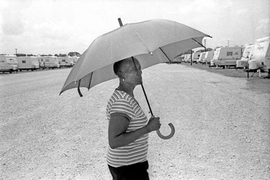
Alan Chin directs me to a photo essay he made in 2007, about a FEMA refugee camp just north of Baton Rouge, Louisiana, called Renaissance Village, where at least 1,500 people displaced by Hurricane Katrina were living in 580 trailers, Alan says, “with virtually no shade, far from any jobs, schools, or churches; minimal public transit.” At the time, the residents complained that something in the camp was making them sick. Later that year, dangerously high levels of formaldehyde were found in the trailers; FEMA shut down the camp in 2008. Most of the black-and-white photographs in the essay are from inside the park: boys astride bicycles pause for a sip of bottled water; two girls goof off on a gravel lot that serves as their communal backyard; a woman passes between rows of trailers carrying an umbrella for shade.

Alan Chin
Renaissance Village, ninety miles from New Orleans near Baton Rouge, Louisiana, July 2007; one of the largest FEMA trailer park camps established to house internally displaced people from Hurricane Katrina in September 2005
“I spent several days in there,” Alan says. “But how do you show this is a whole artificial town versus any place with these issues?” He hired a single-engine airplane at a local airfield, eighty dollars for ten airborne minutes. The purpose, he says, was “more forensic than aesthetic or emotional”: to show the individual suffering in context.
Alan used only one aerial image in his essay; it is the first photograph in the sequence. It shows, at least partially, ninety-two of the Renaissance Village trailers. They are parked back-to-back on short grass in three rows, with gravel and a handful of cars in between. That is all. The frame is tilted, the trailers aslant to the axis of the image, as if the photographer pressed the shutter by accident, or as if the trailers were there by accident, by mistake.
The next image, made at eye level, is of three rows of cluster mailbox units on pedestals, the kind that are made of aircraft aluminum, with sixteen compartments each, and that look like miniature high-rises on stilts. They are not in the aerial shot, and it must take some time to reach them from the trailers that are. Next to the mailboxes is a fire hydrant and a plastic trash can; in the background, outside the perimeter of the camp, some trees. The mailbox units throw short, martially uniform ranks of shade. I try to imagine the woman with the umbrella crossing the sunbaked gravel, opening one of the narrow mailbox doors, and pulling out a letter.
Alan Chin
Renaissance Village, Louisiana, July 2007