One evening in what must have been early 2004, I drove with my friend Edly to see the section of the Wall, or the Separation Barrier, as it is officially called in Israel, that had recently gone up in Abu Dis, a Palestinian neighborhood in east Jerusalem. I knew Abu Dis as it had been before, and I was well aware that the Wall was dividing families and making access to hospitals, schools, markets, cemeteries, and offices difficult or impossible for much of its population. (In general, in the Jerusalem area, the Wall mostly separates Palestinians from Palestinians, not Palestinians from Israelis.) Yet nothing quite prepared us for the sinking feeling of finality, of a psychic and corporeal dead end, that hit us as we suddenly came face to face with these nine-meter-high concrete slabs. For some minutes after reaching the barrier, we sat and stared. Then Edly said: “One day this monstrosity will come down, as happened in Berlin, and when it does people on both sides will dance in joy.”
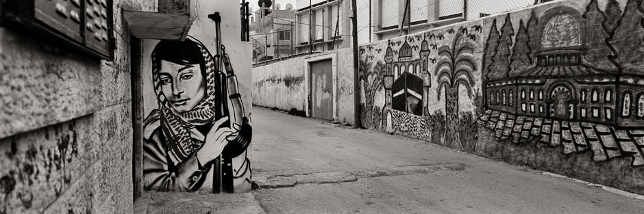
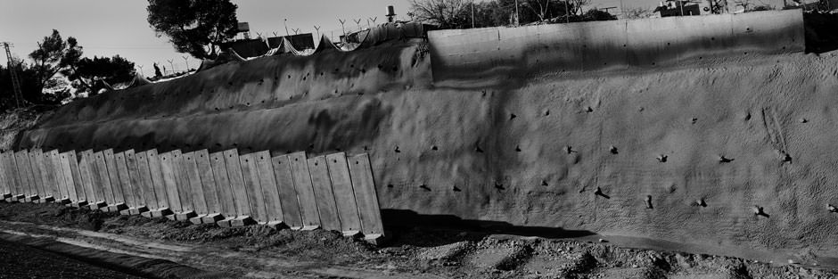
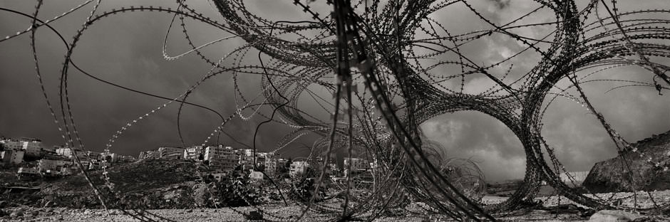
We tend to imagine the Wall as a single, monolithic structure. In reality it is a set or system of walls and fences within walls and fences, a recursive infinite regress of barbed wire, rock, and cement that turns inward as it slithers over the hills, enclosing most Palestinian villages on the occupied West Bank in non-contiguous enclaves even as it incorporates into Israel as many Jewish settlements as possible. Upon completion, its dizzying route is expected to run for over 700 kilometers. If you haven’t seen it with your own eyes but would like to know what it is like, your best option is to study Wall, Josef Koudelka’s new book of eloquent black-and-white photographs, taken over four years in repeated trips to Israel and Palestine. Koudelka, famous for his classic photographs of the Soviet invasion of Czechoslovakia in 1968, has won many prizes, including the Grand Prix Cartier-Bresson (in 1991) and the Medal of Merit of the Czech Republic (2002). This, his eleventh book of photographs reveals a Biblical landscape ravaged by greed and by the desperate illusion that safety, at least some tentative and temporary form of safety, can be found in a big fence.
The Barrier was initially planned by Ariel Sharon during the Second Intifada, when there were frequent Palestinian suicide bombings—a wave of violence that Sharon himself sparked by marching, with about a thousand armed soldiers and police, to the Haram al-Sharif, the Muslim holy places in East Jerusalem, on September 28, 2000. Ostensibly, the purpose of the Wall was to contain Palestinian violence. Probably most Israelis think that its construction is largely responsible for the decline in Palestine attacks against Israelis in recent years. Perhaps, in part, it is. Like most of those who struggled against the Wall, I was and am not, in principle, opposed to a defensive boundary. The trouble lies in the trajectory the government planners chose.
Some 85 percent of the Wall runs not along the Green Line, the pre-1967 Israeli border, but inside, sometimes deep inside, the Palestinian West Bank. Village after village has had its agricultural and grazing grounds fenced off, its olive groves and vineyards ruthlessly uprooted, its fertile valleys annexed as land reserves for existing and future Israeli settlements—which have in turn been formally carved away from the West Bank by the Wall. The Wall has become one more instrument—some would say the most useful of all—in the ongoing land-grab that is the real, indeed perhaps the sole, raison d’être of the Occupation.
From the moment the route was first approved by the government in 2002–2003, it was clear that Sharon himself, along with much of the Israeli center and the so-called moderate right, saw the Wall as marking, or rather forging, the future boundary of the state. There was a need to ensure that as much land as possible lay to the west of the wire and concrete—land which has become a de facto part of Israel. Estimates vary, but according to B’Tselem, the highly reliable human-rights organization, so far about 8.5 percent of the West Bank has been absorbed in Israel by the Wall, and another 3 to 4 percent of the land is encircled by the internal network of fences to the east of the barrier—all this taken from the 22 percent of historic Palestine that the Palestinians were left with in 1948 and that they declared in the Oslo years they would accept as the territory of their future state. What is worse, the portion of what remains of the Palestinian West Bank that has been annexed by the Wall includes areas of land that reach so far into Palestine that they all but preclude the very possibility of a territorially continuous, functional Palestinian state. The Israeli cities of Ariel and its satellite settlements (over ten miles from the Green Line, a third of the way to the Jordan River to the east), in the heart of the northern West Bank, and Efrat, in the south, are but two salient examples.
Advertisement
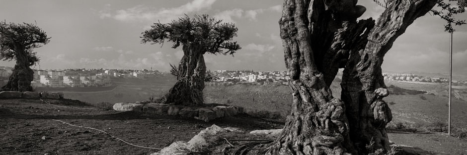
Koudelka’s pictures have an eerie, meditative texture. Many of them are structured around the glaring contrast between the Wall, always intrusive, harsh, ophidian, and the organic, still living world of hills, terraces, and valleys on either side of it. Paradoxically, these photographs are beautiful, almost too beautiful, to look at—despite, or perhaps because of, the raw wound they reveal. Look, for example, at the graveyard of decimated olive trees in an area earmarked for annexation to the east of Jerusalem. I have known Palestinian farmers who treat their olive trees—sometimes their main life support—like beloved children, and who sit in mourning when a tree is killed by settlers or soldiers. (It happened again this month: forty-eight young olive trees were destroyed by settlers at Gawawis in the south Hebron hills.)
Or study the valley just below Beit Jalla, near Bethlehem, where the grey slabs are the only things that still grow. Here hundreds of Palestinian families, whose main source of livelihood was once their vineyards, have been cut off by the Wall from nearly all their markets. The Israeli courts, too, have had their say on the matter. Seventeen villages south of Jerusalem, still in the greater Bethlehem area, lost much of their land to the Wall, including the once astonishingly beautiful and fertile valley in Artas at the north-eastern foot of the huge settlement-city of Efrat, mentioned earlier (the village is named for the “sealed garden,” hortus conclusus in Latin, of Song of Songs 4:12). The villagers appealed to the Supreme Court, which decided that 1) it was not the Court’s business to rule on the legality or illegality of Efrat itself, but 2) since Efrat already existed, it definitely needed a Wall. In the words of Justice Dorit Beinish: “The question of the legality of the settlement of Israeli residents in Efrat is not up for discussion today. This question does not affect the military commander’s responsibility to protect the lives, security and honor of each and every one of the Israeli settlers, and he is authorized to build a security fence for that purpose.” Years of weekly non-violent protests by these unusually imaginative and persistent villagers have not succeeded in shifting the route of the Wall in this sector by so much as a millimeter.
The struggle against the Wall did, however, have two, or two-and-a-half, significant successes. First there was Budrus, a village just north of Jerusalem, whose remarkable nonviolent protests were the subject of a gripping film, Budrus, directed by Julia Bacha of Just Vision. The protests were largely driven by the village women, including a truly heroic teenager, Iltezam Morrar; these women, together with the men and a strong contingent of Israeli and international peace activists, confronted the army bulldozers, jumped into the craters they had opened up in the soil, and survived the endless showers of tear gas and rubber bullets. They continued the protests for more than ten months, ultimately forcing the government to change the route of the Wall, leaving the fields and groves of Budrus intact. (However, Budrus has recently become the object of new harassment by the army, which has resumed its standard program of raids and arrests.)
Budrus-style demonstrations rapidly spread to other villages in the Jerusalem corridor, including Bil’in, which soon became the emblem of this struggle. In Bil’in, one of the several “Palestinian Gandhis” emerged as a leader of the movement—’Abdallah Abu Rahma, who was, of course, incarcerated (for fifteen months), and whose remarkable statements from prison will surely survive as classic documents of non-violent resistance in Palestine. Here he is, for example, on Israeli repression:
I often wonder what Israeli leaders think they will achieve if they succeed in their goal of suppressing the Palestinian popular struggle? Is it possible that they believe that our people can sit quietly and watch as our land is taken from us? Do they think that we can face our children and tell them that, like us, they will never experience freedom? Or do they actually prefer violence and killing to our form of nonviolent struggle because it camouflages their ongoing theft and gives them an excuse to continue using us as guinea pigs for their weapons?
I had the great honor of being arrested together with ‘Abdallah Abu Rahma the first time I went to Bil’in, in 2005. Eventually, in 2007, the Supreme Court ruled that the planned trajectory of the Wall at Bil’in had to be changed and at least a portion of the village lands restored to their owners; it took the army four years to begin to carry out this ruling, which still left about a third of the land in the hands of Israeli settlers. Still, at Budrus and Bil’in the protests achieved a moral victory. Elsewhere, the army has managed to contain, if not entirely to suppress, civil resistance by often violent riot-control techniques (tear gas, rubber bullets, occasionally live ammunition, arrests, beatings, and the peculiar Israeli invention of the Skunk, a vehicle that sprays an unbearable stench on demonstrators). The half-success was achieved in the northern West Bank in the area initially appropriated for a long corridor of Israeli settlement, near Alfei Menashe. Again, the court forced the authorities to redraw the lines.
Advertisement
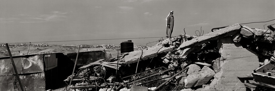
By its very nature, the Wall creates, or in some cases perpetuates and makes operational, cruel anomalies and paradoxes. In Al Walaja, for example, just south of Jerusalem, the land has been officially annexed to Israel while the villagers who reside on it continue to have the status of West Bank residents. What this means is that, now encircled by the Wall, nearly all of them have become illegal aliens while simply sitting in their homes; if they leave the village, they can be arrested at any moment. This section of Wall also reveals the severe ecological damage the whole project has caused; a huge swathe of slope and valley around Wallaja, once designated to become a nature preserve, is being ruined.
A little farther east, the vast Israeli settlement of Har Homa—a perfect example of the architectural style aptly named Israeli Brutalism—is perpetrating another sort of injury. Together with the Wall, which protects it, the settlement and its stone houses have mostly swallowed up what is left of one of the most beautiful of all Palestinian villages, Nu’man, a gentle vestige of Old Palestine, where, again, the remaining villagers now can no longer safely leave their homes. You can’t see the Wall in Koudelka’s picture of Har Homa, but take my word for it: it fits right in. Ugliness, like beauty, has a moral, not merely an existential, valence.
Perhaps human beings can never become fully habituated to ugliness, or leave it alone. The Wall is a favorite site for painting and graffiti by local as well as international artists. These works have been documented and studied in a fine book by Avinoam Shalem, Gerhard Wolf, and the photographer Dror Maayan, Facing the Wall (Thames and Hudson, 2011). You can read some of the graffiti, in several languages, in a few of Koudelka’s photos. In a sense, the Wall is a sort of gigantic billboard-cum-screen: theater groups have used it as backdrop for plays of protest, films have been beamed onto it, and the French photographer JR pasted larger-than-life photographs of Israelis and Palestinians on both sides of it with the aim of demonstrating the kinship and shared humanity of both sides. Even more than was the case in divided Berlin, this tortuous monument is extraordinarily photogenic; Koudelka has captured many of its bitter faces, rendered, if anything, still more bitter by his amazingly nuanced black-and-white tones that have replaced the natural palette of brown-gold-olive green.
In the long term, probably nothing is as transient as a wall. Once it falls, one wonders what it was doing there for so long and why anyone ever bowed to its existence. I’m sure Edly is right; one day this Wall, too, will fall. Even now the Wall is more holes and empty space than solid barrier; perhaps it remains unfinished because its planners know deep down how futile and foolish the whole enterprise is. Fencing some two million innocent, disenfranchised people into a vast open-air prison cannot be a good idea.
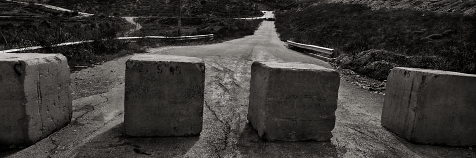
But for now, when I visit my friends in Abu Dis, I take the long, roundabout road through the desert to the east, then turn right past the settlement-suburb of Ma’ale Adumim and go straight through Al-‘Aizariya until I hit what Palestinians routinely call, with some justice, the “apartheid Wall”— the ultimate dead end. It looks alien, lunatic, an arbitrary but far from meaningless marker running the length of the mountain ridge south of Bethany and the Mount of Olives.
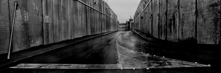
Last time I was there I looked for, and found, the big black inscription on one of the concrete slabs I remembered from 2004: “Scheduled for Demolition: Immoral Building.” Immoral because it’s so ugly? Or because it embodies the ugly principle of ethnic separation as a form of discrimination? Or because it drains away life and color and hope? To my mind the most powerful of Koudelka’s images is the final one in the book: Wall to the left, Wall to the right, a menacing emptiness in between, a lifeless place fixed in concrete and leading nowhere, despite the sadly hopeful sign pasted on the left-hand wall, pointing one way to Jerusalem, and the other way to Rachel’s Tomb, where the Matriarch Rachel weeps for her children.
Josef Koudelka’s photographs are drawn from his new book Wall, published by Aperture.
